

Where are the hurricanes? 2025 season starts off quiet despite stormy outlook

Hurricane season begins in Florida: How to protect your home
The 2025 Atlantic hurricane season runs June 1 through Nov. 30. FOX 35 Storm Team Meteorologist Brooks Garner shares how to protect your home should a natural disaster occur.
ORLANDO, Fla. - As we head toward late-June, our hurricane season typically heats up. In fact, we're coming up on the one-year anniversary of the development of Hurricane Beryl – the earliest Category 5 in Atlantic history!
Beryl was also the second named system of the season. But this year? We've yet to even have a tropical depression form, much less a tropical storm. So what gives?
It's been crickets quiet
The backstory:
The Atlantic basin, which includes the Gulf and Caribbean, has broken a decade-long streak of busy starts. In fact, June 1–20 in the last 10 years has produced at least one storm, the Washington Post reported. That alone makes this the slowest start in a decade, and we have little chance to see any meaningful development in the Atlantic through the end of June.
RELATED | 2025 Atlantic hurricane season storm names: See full list
It's not just us
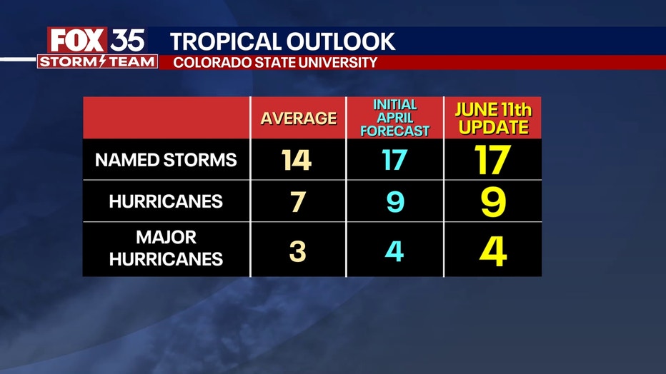
In a bigger scope, it's been really quiet across all ocean basins in the Northern Hemisphere. As of mid-May – before the eastern Pacific activated with now the fifth named storm – 2025 would share a spot with only five other seasons since the mid-20th century when the entire Northern Hemisphere was free of named systems. These years were 1973, 1983, 1984, 1998, and 2024. This, according to Colorado State University Meteorologist Dr. Phil Klotzbach.
Does this mean a slower season?
Dig deeper:
That said, this may not be an indication we're going to enjoy a slower hurricane season. In fact, the major hurricane seasonal forecasters are still gunning for a slightly above-normal hurricane season. As always in risk assessment, it's critically important to consider that even in the slowest years, it only takes one landfalling hurricane to make for the "worst season".

NHC to use AI to track hurricanes
NOAA Deputy Director Jamie Rhode weighs in on the National Hurricane Center (NHC) using artificial intelligence to track hurricanes.
MORE: Tracking The Tropics: FOX 35 2025 Hurricane Season Preview
Hurricane Andrew in 1992 was a case in point, being that season's FIRST named system not happening until Mid-August, but slamming South Florida as a major hurricane and forever changing life here, setting a benchmark in both disaster management and building codes.
However, delayed starts don't necessarily mean a quiet season. Consider 2005, which started slowly with the first hurricane not forming until Cindy in early July. The season would ultimately produce a record 28 named systems, including historic Cat. 5's Hurricane Katrina and Rita.
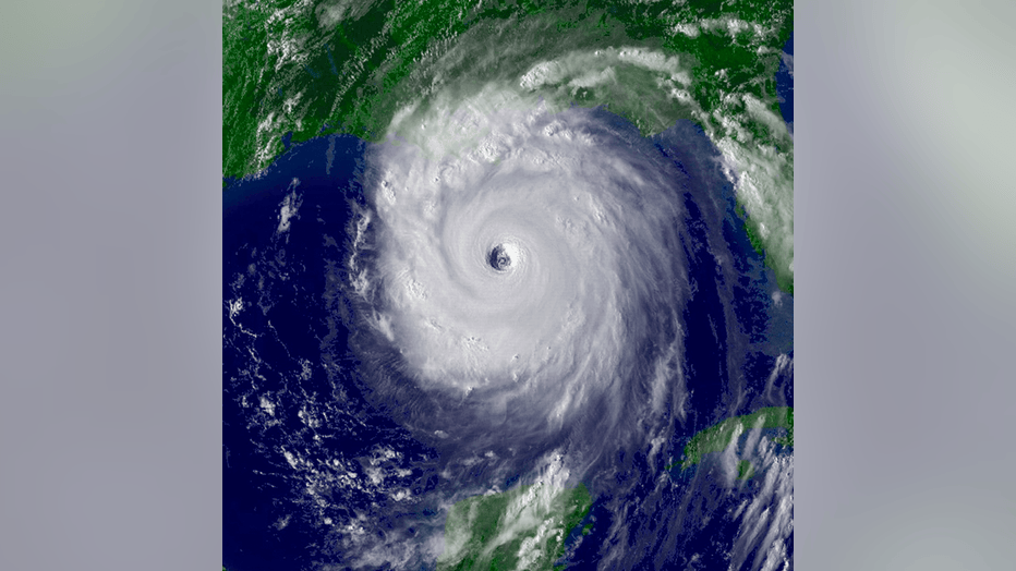
Satellite image of Hurricane Katrina in 2005 (Credit: NOAA)
Why the delay?
What we know:
Ironically, one element may be due to warmer than normal waters in the subtropical oceans closely matching slightly cooler than normal to near-normal waters in the tropical oceans, reducing the wind gradient between the temperatures change zones, according to Ben Noll, tropical expert.
When one thinks of "warmer water", it would be logical to conclude this might mean more fuel for hurricanes, but in this context, it actually leads to more stable air and less thunderstorm formation as the temperature contrast is lower. Fewer thunderstorms mean less chance for tropical systems to organize.
A second factor: unusual busy bursts of Saharan dust have also been pushed into the Atlantic, producing much more stable air than otherwise over the zones conducive to otherwise support tropical development. That may help to further reduce the intensity of tropical waves.
RELATED | 2025 Hurricane Season: What to know and how to be prepared
The bottom line
Big picture view:
Other factors are at work too, making for a quiet start, but this crawl to the line doesn't necessarily mean the pattern will hold. Even if this trend continues like it did in 1992 with just six named tropical systems total (when typically we see 14 named storms), it only takes a hurricane like Andrew (Aug. 1992) to change life in its landfall zone for a long time.
More info: NOAA 2025 Atlantic hurricane season forecast
This year, with seasonal forecasts remaining bullish for a higher storm count, we may be faced with several powerful tropical systems.
STAY CONNECTED WITH FOX 35 ORLANDO:
- Download the FOX Local app for breaking news alerts, the latest news headlines
- Download the FOX 35 Storm Team Weather app for weather alerts & radar
- Sign up for FOX 35's daily newsletter for the latest morning headlines
- FOX Local: Stream FOX 35 newscasts, FOX 35 News+, Central Florida Eats on your smart TV
The Source: This story was written based on information shared by the National Hurricane Center, Colorado State University Meteorologist Dr. Phil Klotzbach and reporting from the Washington Post on June 18, 2025.